Strategic Road Safety Enhancements in Tel Aviv: A Data-Driven Approach with Digital Twin Innovations
March 2024
Executive Overview and Key Findings
Florentin neighborhood in Tel Aviv presents a unique urban challenge, combining dense residential and commercial use with high traffic volumes, leading to a significant road safety concern. This report outlines Cognata’s strategic approach to mitigate road accidents and enhance safety, leveraging advanced digital-twin technology, research tools, and a Holistic Safety approach.
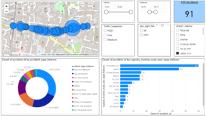
- Accident Hotspots Identified: Analysis pinpointed specific areas, including Eilat Road, Salame Road, and Abrabanel Street, where a notable concentration of accidents occurred, suggesting these locations as priority areas for intervention.
- The involvement of motorcycles in a significant number of fatal accidents underscores the urgent need for speed regulation among these vehicles. Implementing motorcycle speed limitations emerges as a vital strategy to reduce the severity and likelihood of accidents, safeguarding both motorcyclists and other road users.
- The report emphasizes the efficacy of simple and cost-effective measures to improve drivers’ and pedestrians’ line of sight. By enhancing visibility at crucial points, such interventions are poised to significantly increase reaction times, thereby preventing accidents and improving the safety of all urban commuters.
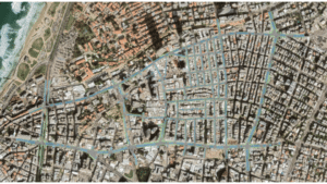
Digital Twin Map Coverage: Covering most streets between Aliyah Street from the east, Eilat Road and Yefo from the north, Jerusalem Boulevard from the east, and Salame Road from the south.
Introduction
This initiative, spearheaded by Cognata, leverages advanced digital twin technology to meticulously analyze and propose solutions aimed at reducing road accidents, aligning with the city’s Vision Zero goal. By synergizing comprehensive accident data analysis with pioneering digital twin simulations, the project not only aligns with but also advances the Vision Zero goal to eliminate traffic fatalities and severe injuries.
Analytical Framework and Methodology
The project embarked on a comprehensive approach, starting with the analysis of existing road conditions and accident data within Florentin. Our methodology integrates robust historical data analysis, focusing on accident trends from 2017 to 2023, with advanced digital twin technology to create a predictive model of urban traffic dynamics. This dual approach facilitates a nuanced understanding of the risk factors contributing to the high accident rate in key areas.
General Data Overview: Data includes accidents occurring between 2017-2023 with injuries only, on Salame Road between Rabbi Meir Street and Haim Vital Street. Data source: Project Anyway and Google Maps traffic load data.
Digital Twin Technology: A Cornerstone of the Project
The digital twin of Florentin has been instrumental in our analysis, serving as a virtual testing ground for proposed safety measures. This innovative technology enabled us to:
- Visualize and Simulate: Detailed recreations of traffic patterns and pedestrian movements at critical intersections provided insights beyond traditional data analysis.
- Evaluate Interventions: The digital twin allowed for the virtual implementation and assessment of safety recommendations, demonstrating their potential impact on reducing accidents and enhancing pedestrian safety.
- Optimize Strategic Decisions: By simulating various intervention scenarios, we identified the most effective measures, ensuring resource allocation for optimal safety improvements.
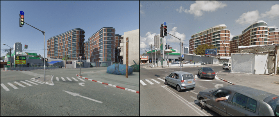
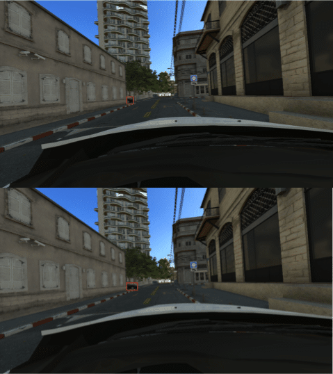
Digital Twin vs. Real Life: A side-by-side comparison of the digital twin simulation and real-life imagery.
What have we learned?
Analysis of traffic and accident data revealed some critical insights, such as:
- Motorcycles were involved in over half the number of accidents, highlighting the need for targeted safety measures.
- One particular junction was identified as a hotspot for accidents with a third of the accidents in its area.
- Significant accidents were recorded along the target road, with a disproportionate number occurring during daylight and under moderate traffic congestion.
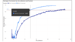
Based on these insights, we recommend adjusting specific stop lines, for enhanced visibility at intersections could significantly reduce vehicle-pedestrian conflicts, as demonstrated in digital twin simulations. One such example proved that moving the stop line position by only 50 centimeters could help double the response time of both vehicles entering the road, and vehicles driving on the main road. We have also recommended implementing several speed reduction measures, including the introduction of rumble strips, which have shown potential in digital simulations to lower accident probabilities by 60%, especially involving motorcycles.
Vehicle Integration Distance vs. Concealment Level: Comparing the stop line location before the sidewalk (current situation) to the stop line location at the edge of the road (proposed situation).
Viewpoint with the Stop Line at the Sidewalk Vs. Viewpoint with the Stop Line at the Road Edge
Looking forward
The Florentin project underscores the transformative potential of digital twin technology in urban safety planning. By providing a detailed, data-driven view of urban environments and the impacts of potential interventions, digital twins can guide more informed decision-making and policy development. This project not only offers a blueprint for enhancing safety in Florentin but also serves as a model for other urban areas grappling with similar challenges.
By enabling municipalities to visualize complex urban environments and the outcomes of various interventions, this technology empowers decision-makers to prioritize and implement the most effective, cost-efficient safety measures. Importantly, it demonstrates that enhancing traffic safety and maintaining smooth traffic flow are not mutually exclusive goals. Through precise simulation and analysis, urban planners can identify interventions that achieve both, thereby fostering safer, more efficient urban spaces.
